This article covers what qualifies as an oversized load, the key constraints planners must evaluate, a step-by-step planning process, the tools and technology available today, and the most common mistakes to avoid. According to the Federal Highway Administration (FHWA), states issue millions of OS/OW permits annually, with demand driven by infrastructure projects, renewable energy buildouts (wind turbine components), and industrial freight—sectors where routing precision directly impacts project economics and safety records.
TLDR
- Loads exceeding 8.5 ft wide, 13.5–14 ft tall, 53 ft long, or 80,000 lbs trigger OS/OW classification
- Route planning must clear bridge weight limits, height obstructions, road widths, turning radii, and multi-state permits
- The process: load assessment → constraint mapping → route survey → permitting → escort planning → execution
- GIS dashboards, state DOT tools, and truck-routing APIs automate constraint checks
- Skipping field surveys, underestimating permit timelines, or missing local ordinances are the most common—and avoidable—failures
What Qualifies as an Oversized Load?
Federal thresholds define oversized classification:
- Width: Over 8 feet 6 inches (102 inches)
- Height: Approximately 13 feet 6 inches to 14 feet (varies by state)
- Length: Beyond 53 feet for standard trailer combinations
- Gross weight: Exceeding 80,000 lbs
Exceeding any single threshold triggers oversized classification. Under 23 CFR 658.15, states may not impose width limits more or less restrictive than 102 inches on the National Network, though they may grant special permits for wider loads.
Each dimension category introduces a distinct set of routing constraints — and planners need to know which applies before mapping a single mile.
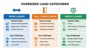
Three Primary Categories
| Category | Typical Cargo | Key Routing Challenge |
|---|---|---|
| Wide loads | Construction equipment, agricultural machinery, prefab structures | Guardrail clearance, intersection geometry, lane width |
| Tall/high loads | Industrial machinery, aircraft components, shipping containers | Overhead clearances at bridges, power lines, traffic signals |
| Heavy loads | Cranes, bulldozers, wind turbine components, transformers | Bridge weight ratings, pavement strength, axle load distribution |
Non-Divisible Loads
The key regulatory trigger for OS/OW permits is the "non-divisible load" designation—loads that cannot be separated without loss of function or at excessive cost. FHWA guidance defines this as cargo that, if divided, would compromise structural integrity or require excessive reassembly cost. Wind turbine blades, industrial pressure vessels, prefabricated building modules, and large power transformers are common examples.
Key Route Constraints in Oversized Load Planning
Physical Infrastructure Constraints
Bridge clearances and weight limits are the most critical chokepoints:
- The federal bridge formula governs maximum weight over consecutive axles to protect infrastructure
- Planners must cross-reference load axle configurations against bridge ratings on every segment
- Posted weight limits may be lower than structural capacity during spring thaw or flood conditions
Overhead clearance hazards extend beyond bridges:
- Power lines and utility cables
- Traffic signals and signage
- Tree canopies on rural corridors
- Railroad overpasses
Many of these hazards don't appear in standard navigation databases at all — physical route surveys remain the only reliable way to confirm clearances before the move.
Road geometry introduces a separate set of constraints that bridge data alone won't catch.
Road Geometry Constraints
Planners must account for:
- Pavement width: Guardrail-to-guardrail measurement for wide loads
- Turning radii: At intersections and roundabouts — roundabouts are among the most common failure points for long or wide loads
- Grade/slope limitations: Steep grades limit traction and braking for heavy loads
- Soft shoulder risks: Narrow shoulders increase rollover risk on curves
Once the physical path is mapped, the regulatory layer determines whether that path is legally passable — and under what conditions.
Regulatory Constraint Layer
State OS/OW permit rules vary significantly:
- Some states allow self-issued permits below certain thresholds (for example, 14 ft wide, 14 ft 6 in tall, 110 ft long in many auto-issuance systems)
- Superloads trigger full engineering review, typically taking 2–6 weeks depending on the state
- Multi-state moves multiply the complexity — each jurisdiction has its own dimension limits, escort requirements, and travel hour restrictions
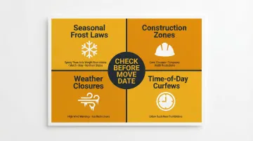
Dynamic/Temporary Constraints
These must be checked close to the move date, not just at permit application:
- Seasonal frost laws: Restrict axle weights during spring thaw (typically March–May in northern states like Michigan, Minnesota, Wisconsin)
- Construction zones: Lane closures and temporary width restrictions
- Weather-related road closures: High wind warnings, ice restrictions
- Time-of-day curfews: Urban areas often prohibit oversized moves during rush hours
How to Plan an Oversized Load Route: Step-by-Step
Step 1: Assess Load Dimensions and Equipment Needs
Confirm exact measurements:
- Height, width, length, weight
- Overhang (front and rear)
- Number and configuration of axles
- Steerable axles and air suspension adjustability
Even a few inches of variance in trailer configuration or load securement can affect vertical clearance or turning feasibility. Resolve equipment selection (lowboy, RGN, extendable flatbed, multi-axle) before route analysis begins.
Step 2: Map Route Constraints and Identify a Candidate Corridor
Use state DOT GIS tools to overlay:
- Bridge clearance data
- Posted weight limits
- Height-restricted structures
- Road width data
Tools by state:
- New York: NY DOT pre-screening tool for bridge restrictions and height-limited structures
- California: Caltrans CalRoute with bridge clearance tables and weight charts
- Colorado: DOT freight restriction dashboard
- Texas: Designated OS/OW corridors with pre-validated infrastructure
Identify preferred OS/OW corridors where available—states like Texas maintain designated networks that streamline permitting.
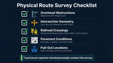
Step 3: Conduct a Physical Route Survey
Digital tools cannot replace ground-level verification. The route survey should document:
- Overhead obstructions: Measured with a height pole
- Tight intersection geometry: Turn-by-turn clearance verification
- Railroad crossings: Measure distance between tracks and nearest traffic control device to ensure the load can clear
- Pavement conditions: Potholes, cracking, shoulder width
- Safe pull-out/overnight parking locations
FHWA recommendation: The lead pilot/escort vehicle operator should conduct the survey so they are personally familiar with every hazard.
With the physical survey complete, you have the verified data needed to submit accurate permit applications across every jurisdiction on the route.
Step 4: Secure Permits Across All Jurisdictions
Submit applications to every state, county, and municipal authority whose roads are on the route. Each may have different:
- Dimension limits
- Escort requirements
- Allowed travel hours
- Insurance/bond requirements
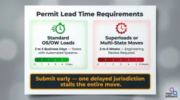
Lead time requirements:
- Standard OS/OW loads: 3–5 business days in states with automated systems
- Superloads or multi-state moves: Weeks for engineering review
Permit applications must specify the exact route — deviating from it in most states constitutes a permit violation.
Step 5: Coordinate Escort Vehicles, Safety Resources, and Communications
Determine escort requirements per jurisdiction:
- Number of pilot/escort vehicles (lead and/or rear)
- Law enforcement escort mandates
Equip escort vehicles with:
- Height poles
- Two-way radios
- Dashboard cameras
- Proper signage (OVERSIZE LOAD)
Before departure, build emergency contact lists covering every entity you may need to reach mid-move:
- Law enforcement
- Utility companies
- Railroads
- Local DOT contacts for every jurisdiction
Conduct a pre-trip briefing with driver and all escort operators covering every known hazard. That briefing is also the last checkpoint before final execution planning begins.
Step 6: Execute with Real-Time Monitoring and Contingency Readiness
Before departure:
- Recheck DOT alerts and 511 systems
- Verify weather forecasts
- Confirm fuel stops with adequate turning radius and pull-through parking
- Ensure a pre-approved alternate route is documented
During transit:
- Maintain continuous communication between driver and dispatchers
- Document any route deviations or unexpected conditions for compliance records
- Update routing databases with findings to improve future planning accuracy
Essential Tools and Technology for Oversized Load Route Planning
State DOT Pre-Screening and GIS Tools
According to FHWA best practices research, 30+ states have automated permit systems with integrated routing modules. Examples include:
- NY DOT's oversize/overweight pre-screening tool: Bridge restrictions, height-restricted structures
- Caltrans CalRoute: Bridge clearance tables, weight charts, red route summaries
- Colorado DOT's freight restriction dashboard: Real-time restriction overlays
How to use them: These tools serve as the first digital pass before field verification. They expose data layers for bridge clearances, weight limits, and road classifications that are not available in consumer navigation apps.
Truck-Specific Routing APIs and Route Optimization Software
Unlike general-purpose navigation, truck-routing APIs allow planners to input vehicle-specific parameters:
- Height
- Width
- Gross weight
- Axle configuration
The system algorithmically avoids bridges below clearance thresholds, weight-restricted roads, and road classes incompatible with the load dimensions.
Platforms like NextBillion.ai's routing API support 50+ hard and soft constraints (vehicle height, weight, axle load, and custom road attribute filters). This lets carriers and fleet software developers replace manual lookups against static maps with an automated, constraint-aware routing process.
Real-Time and Dynamic Data Integration
Digital pre-screening only gets you so far. A route validated weeks in advance can become invalid the day of the move — integrate live data sources to catch late-breaking changes:
- Live construction zone data
- 511 traveler information feeds
- Weather alerts
- Temporary closure notifications
Together, these feeds inform final go/no-go decisions and give dispatchers the situational awareness to redirect a load mid-transit when conditions change.
Physical Survey Tools
Digital tools narrow the candidate routes, but physical surveys confirm what the data can't always capture. Standard field verification equipment includes:
- Height poles: Measure overhead clearances during route surveys
- Measuring devices: Road width and intersection geometry
- Dashboard cameras and still cameras: Document hazards
- GPS devices with topographic overlays
- Drone-based photogrammetry: Complex infrastructure assessments
Survey findings should feed back into routing databases — each corrected data point reduces manual verification time on future moves over the same corridor.
Emerging Technology Trends
- LiDAR and BIM-based 3D infrastructure modeling: More precise clearance data on complex bridge and interchange geometry
- Multi-state corridor routing systems: NCHRP Report 830 calls for unified OS/OW permit and route systems across state lines
- Telematics integration: Real-time position monitoring and dynamic re-routing during transit
Operational Tips for Safe and Compliant Execution
Timing and Scheduling Strategy
- Off-peak timing: Plan moves during off-peak hours or overnight where permitted to reduce traffic interaction and urban curfew conflicts
- Account for seasonal constraints: Frost laws in northern states (Michigan, Minnesota, Wisconsin, North Dakota, Montana) typically restrict axle weights during spring thaw periods—March through May—when pavement is most vulnerable
- Permit lead times: Track each jurisdiction's processing window separately, particularly for multi-state superloads requiring engineering review — submit well ahead of your move date
Pilot/Escort Vehicle Best Practices
- The route survey should be conducted by the same person who will serve as lead escort operator (per FHWA Module 3 guidance)
- Ensure all team members use consistent lane terminology and radio communication protocols
- Verify escort vehicles are properly equipped with height poles, oversize load signage, flashing lights, and emergency contact lists before departure
Contingency and Risk Management
- Always identify and document a pre-approved alternate route before departure
- Carry adequate insurance and bonding per permit requirements — bridge crossings and tight urban corridors often trigger higher liability thresholds
- Re-verify clearances and check DOT alerts the day before and morning of the move — not just at the permit application stage
Common Oversized Load Route Planning Mistakes to Avoid
Even experienced carriers run into costly delays — usually because of a few recurring mistakes. Here's where oversized load moves most commonly go wrong.
Over-Reliance on Digital Maps Without Field Verification
GIS dashboards and routing software are powerful screening tools, but they can't capture every real-world condition:
- Newly posted bridge restrictions
- Recently installed utility lines
- Construction that narrows a lane
- Grade changes at an intersection
Always supplement digital route identification with a physical survey, especially at known pinch points like interchanges, tight turns, and older infrastructure corridors.
Overlooking Local and Municipal Permit Requirements
State permits don't automatically authorize travel on every county or municipal road. Local jurisdictions can also impose:
- Additional axle weight restrictions
- Time-of-day bans
- Lower clearance limits
- Separate permit fees
Contact county engineers and city transportation offices early in the planning process to identify any local-layer requirements that could block or re-route the move.
Underestimating Permit Timelines and Missing the Multi-Jurisdiction Complexity
Permit timelines vary widely — and a single delayed jurisdiction can stall the entire move:
- Standard OS/OW moves: 3–5 business days in states with automated systems
- Superloads or multi-state moves: 2–6 weeks for engineering review
Submit applications as early as possible and build explicit buffer time into project schedules. The more jurisdictions involved, the higher the odds of one falling behind.
Frequently Asked Questions
What is the widest load you can carry without a permit?
Most states allow loads up to 8 feet 6 inches wide without a special oversized permit, aligning with the federal highway width limit. Thresholds can vary slightly by state—some require permits for anything over 8 feet—so carriers should verify specific rules for each state on their route.
What is the maximum height for an oversized load?
Loads over approximately 13 feet 6 inches to 14 feet are generally classified as oversized, though the exact threshold varies by state. There is no universal maximum—extremely tall loads require case-by-case routing to identify overhead clearances, and some states impose height caps while others allow taller loads with added conditions.
How much does a wide load permit cost in Texas?
Texas permit fees for oversized/overweight loads vary based on load dimensions and gross weight. For example, a single-trip permit for a load weighing 80,001–120,000 lbs costs $210 ($60 base fee + $150 highway maintenance fee). The total cost of moving a wide load includes more than the permit fee—escort vehicles, route surveys, and bonding requirements add to the total.
How to read oversize load permits?
Oversized load permits typically specify:
- Authorized route: origin, destination, required turns or corridors
- Dimension and weight limits approved for that trip
- Allowed travel hours and days
- Escort requirements and any special conditions (utility coordination, law enforcement)
Deviating from the permitted route in most states renders the permit invalid.
What is the 40 foot rule in California?
California's "40-foot rule" under CVC Section 35400 caps single-unit vehicle length at 40 feet, including any trailer being towed. For truck-tractor/semitrailer combinations, the semitrailer may not exceed 48 feet (or 53 feet if kingpin-to-rearmost-axle requirements are met). Overhang limits are governed separately.
Are oversize loads exempt from 30 minute break?
Yes — the FMCSA has granted OS/OW drivers an exemption from the mandatory 30-minute rest break under 49 CFR 395.3(a)(3)(ii). It applies to drivers of permitted, interstate specialized loads that exceed normal size or weight limits. The current exemption runs June 17, 2025 through June 17, 2030; drivers must carry a copy of the Federal Register notice while operating under it.