How does NextBillion.ai handle routing for oversized and overweight loads?
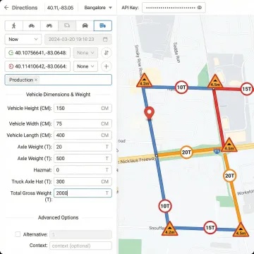
NextBillion.ai's routing engine accepts precise vehicle parameters — height, width, weight, axle load, and length — and generates routes that automatically avoid low-clearance bridges, weight-restricted roads, sharp turns, and truck-prohibited corridors. This means every route is calculated against the actual physical constraints of the permitted load, not generic car-routing assumptions that collapse on the first weight-restricted bridge.
Can I input permit-approved corridors and road restrictions into the routing engine?
Yes. The Road Editor App allows operations teams to inject custom road attributes — including permit-approved haul corridors, municipal plying permissions, no-entry zones, and construction-related closures — directly into the routing engine without any developer involvement. Every subsequent route calculation immediately reflects these custom attributes, ensuring planned routes stay within permit boundaries.
Does the platform support compliance documentation for regulated heavy haul operations?
The Route Reconstruction API produces complete, road-snapped trip records from GPS data — providing time-stamped, road-network-aligned journey documentation that satisfies regulatory audit requirements for commercial trucking. These records include road segment identifiers, timestamps, and distance data, forming a legally defensible compliance trail for every permitted haul movement.
How does vehicle dimension input affect route and ETA calculations?
When you specify vehicle dimensions — height, weight, axle load, and cargo type including hazardous materials — every route and ETA calculation is filtered against bridge clearances, weight limits, and road classification restrictions on the active road network. The result is mileage and transit time estimates that reflect what the specified vehicle will actually encounter, not idealized car-routing estimates.
What vehicle types and constraint configurations does the routing API support?
The platform supports cars, motorcycles, light delivery vans, and heavy goods vehicles. For HGV configurations, you can specify height, width, gross weight, axle load, and cargo type. Route preferences include toll avoidance, ferry avoidance, shortest vs. fastest path, and hazardous material routing rules. All constraints are available via API and through the no-code Route Planner App interface.
Can road restrictions be applied based on vehicle type, time of day, or day of week?
Yes. The Road Editor App supports scoped road attribute rules — a restriction can apply only to trucks, only during specific hours (for example, 7am–9am on weekdays to reflect a bus lane rule), or only on certain dates. This granularity allows operators to model complex, time-varying regulatory environments precisely, ensuring routes reflect real-world permit and municipal restrictions without affecting other vehicle classes.
How does live tracking support oversized load monitoring and compliance?
The Live Tracking API monitors permitted load movements in real time with up to 1-meter location accuracy. Configurable alerts notify operations teams of route deviations from permitted corridors, unauthorized stops, and boundary violations. Offline tracking buffers location data during connectivity gaps and syncs upon restoration, ensuring a continuous, complete location history for compliance documentation even through tunnels and low-connectivity industrial zones.
What does integration and deployment look like for a heavy haul logistics operation?
NextBillion.ai integrates with TMS, ERP, telematics platforms (Samsara, Geotab), and custom fleet applications via REST API. Cloud deployment is available on AWS, Google Cloud, and Azure, with an on-premise option for organizations with data residency requirements. The platform goes live within a week, with dedicated onboarding support from NextBillion.ai's solutions engineering team throughout trial, testing, and production integration.