According to the American Transportation Research Institute, traffic congestion added $108.8 billion in costs to the trucking industry in 2022, resulting in 1.27 billion hours of delay and 6.4 billion gallons of wasted diesel fuel. These losses aren't inevitable—they stem from the fundamental disconnect between static route planning and dynamic road conditions.
Real-time GPS fleet tracking closes this gap. When paired with a capable route optimization engine, GPS tracking transforms from a simple "where are my vehicles?" tool into an active system that continuously recalculates the best possible route at any given moment.
TLDR:
- Static route planning degrades throughout the day as traffic, delays, and new orders emerge
- Real-time GPS feeds live vehicle positions into optimization engines that dynamically reroute and resequence stops
- Advanced systems handle 50+ operational constraints beyond basic navigation (time windows, capacity, HOS compliance)
- GPS-driven optimization typically delivers 15-25% fuel savings and significant on-time delivery improvements
- API-first platforms enable seamless integration with existing telematics hardware and dispatch systems
The Limits of Static Route Planning
Traditional route planning happens once—typically the night before or early morning—using fixed assumptions about traffic, stop order, and travel times. Dispatchers sequence jobs, assign drivers, and send everyone out with printed manifests or static digital routes. Those assumptions are obsolete before the first vehicle hits the road.
A single unexpected traffic incident triggers a familiar cascade of problems:
- Missed delivery windows as drivers sit in unplanned congestion
- Idle drivers awaiting new instructions with no real-time guidance
- Frustrated customers tracking orders that have quietly gone off-schedule
Dispatchers spend their days managing these disruptions reactively. When one driver falls behind, it compresses the entire fleet's capacity to handle new jobs — and the effect compounds fast.
The core problem is the absence of a live feedback loop. Without real-time GPS data feeding back into the routing logic, even well-planned routes degrade hour by hour. Empty (deadhead) miles rose to an average of 16.7% of total fleet miles in 2024, representing significant operational waste that static planning simply can't prevent.
How Real-Time GPS Fleet Tracking Enables Route Optimization
The Foundation: Continuous Position Data
GPS devices in vehicles continuously transmit location, speed, and heading data to a central platform. This live positional data serves as the input layer that a route optimization engine needs to make dynamic routing decisions—not just at dispatch, but continuously.
The system uses live GPS data to detect when a vehicle is falling behind schedule—whether due to traffic, a longer stop, or a breakdown—and automatically triggers a recalculation. The optimization engine redistributes stops or resequences remaining jobs across the fleet to prevent cascading delays.
Real-Time Traffic Integration
GPS platforms pull in live traffic feeds showing accidents, congestion, and road closures. When combined with vehicle position data, the system reroutes drivers around disruptions before they cause delays—not after drivers are already stuck. This proactive rerouting prevents the compounding effect where one delayed vehicle creates bottlenecks for subsequent stops.
Dynamic Dispatching for Mid-Shift Changes
When a new urgent order arrives mid-shift, the system identifies which vehicle is geographically closest and has the right remaining capacity. It then inserts the new stop into an optimized sequence without disrupting the rest of the route. That same data doesn't disappear once the stop is completed.
Every trip feeds information back into the optimization engine — actual travel times, stop durations, and route deviations. Over time, this creates a self-improving loop that makes future recommendations more accurate for specific corridors, times of day, and vehicle types.
Key outputs from the feedback loop include:
- More precise ETAs based on real historical travel patterns
- Adjusted stop duration estimates by location and vehicle type
- Corridor-level accuracy improvements that sharpen future dispatching decisions
Key Route Optimization Capabilities Unlocked by Real-Time GPS
Constraint-Based Multi-Stop Optimization
Real-time GPS alone isn't enough. It has to work alongside an optimization engine that handles multiple simultaneous constraints — because basic navigation apps only optimize for shortest distance, and enterprise operations require far more:
- Vehicle load capacity (weight, volume, multi-dimensional)
- Driver hours-of-service compliance
- Customer delivery time windows
- Road type restrictions (truck-prohibited roads, height/weight limits)
- Priority stops and service-level agreements
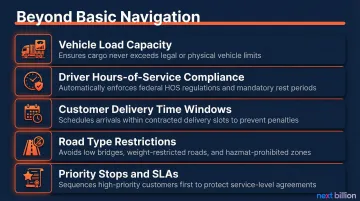
Enterprise-grade solutions like NextBillion.ai's route optimization API support 50+ hard and soft constraints, enabling fleet operators to reflect real operational rules in every route generated, not just map distance. This matters most for trucking, NEMT, and field service fleets where regulatory or contractual requirements aren't optional.
Once constraints are properly encoded, the next layer of intelligence comes from the data your fleet has already generated.
Historical Data and Predictive Routing
Accumulated GPS history reveals patterns: stop dwell times, traffic by time of day, driver performance on specific routes. This data enables predictive routing. The system anticipates delays before they happen rather than waiting until drivers are already stuck.
Example: A delivery fleet operating in a metro area uses historical GPS data showing that a particular corridor is 40% slower on weekday afternoons. The system pre-routes drivers away from it during that window rather than rerouting them after they're already stuck.
According to research from project44, machine learning models predicting residual delays caused by dwell times and disruptions improved ETA accuracy by 28 percentage points at the 10-hour horizon compared to standard mapping APIs.
That predictive intelligence becomes even more valuable when dispatchers can see the full fleet in real time.
Fleet-Wide Visibility and Coordinated Dispatch
Real-time GPS gives dispatchers a live map of every vehicle's position, status, and remaining workload — transforming dispatch from a reactive guessing game into a coordinated, data-driven operation. According to a Samsara case study, digitizing workflows and using a unified dispatch platform cut route communication time by 93% and saved $7.75 million across a single enterprise fleet.
Coordinated dispatch prevents common inefficiencies:
- Two drivers heading to the same area from opposite ends
- An idle vehicle sitting near an urgent stop while a distant vehicle is dispatched
- Drivers completing routes early without taking on additional available jobs
- Dispatchers unaware of which vehicles have capacity for last-minute orders
Measurable Business Outcomes of GPS-Driven Route Optimization
Fuel Cost Reduction
Optimized routing directly reduces total miles driven per day across the fleet. Shorter, smarter routes mean less fuel burned—and reduced idling from drivers sitting in avoidable traffic compounds those savings.
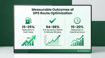
Route optimization software typically delivers 15-25% fuel reduction for last-mile delivery services through stop sequence optimization and traffic avoidance. When you consider that fuel costs averaged $0.481 per mile in 2024, representing approximately 21.2% of the total average marginal cost of operating a truck, these savings translate directly to bottom-line profitability.
The EPA adds that a typical long-haul combination truck that eliminates unnecessary idling can save over 900 gallons of fuel each year.
On-Time Delivery Improvement
Dynamic rerouting and proactive ETA updates improve on-time performance and customer satisfaction. When a driver's live GPS position changes the estimated arrival, the system automatically sends updates to customers—reducing "Where Is My Order?" calls to dispatch.
The numbers put the stakes in sharp focus:
- 79% of shoppers won't return after a late delivery, costing businesses an average of $200-$300 per lost customer
- ML-driven systems achieve 94-98% ETA accuracy within a 5-minute window, versus 60-70% for traditional systems
- Retailers using proactive multi-touch notification sequences report WISMO contact rate reductions of 30-35%
Labor and Overtime Reduction
When routes are optimized continuously, drivers complete their assigned stops in less time—reducing overtime hours, preventing burnout, and allowing fleet managers to rightsize staffing to actual workload.
According to US Fleet Tracking, automated routing and dispatch optimization reduce overtime hours by 15-20% annually and improve job completion rates by 25-30%. Driver wages and benefits represent 44% of total average truck operating costs in 2024—so any reduction in overtime hours directly moves the needle.
Role ambiguity and inefficient scheduling—often caused by poor route planning—significantly impact truck driver exhaustion, cynicism, and inefficacy, the three primary drivers of driver turnover.
Vehicle Wear and Compliance
Fewer total miles and avoidance of inappropriate road types reduce vehicle wear and maintenance costs. Two figures illustrate the financial exposure this addresses:
- At $0.198 per mile (2024 industry average), every unnecessary mile eliminated is a direct maintenance deferral
- FMCSA civil penalties for Hours-of-Service violations reach $19,246 per violation for motor carriers and $4,812 per violation for drivers in 2026
Built-in HOS compliance logic in the optimization engine helps fleets avoid both categories of cost.
What to Look for in a GPS-Integrated Route Optimization Solution
Integration Depth with Existing GPS/Telematics Hardware
The route optimization layer needs to connect directly with the fleet's existing GPS telematics provider—Samsara, Geotab, Motive—so live vehicle data flows automatically into the optimization engine without manual re-entry or platform switching.
70% of commercial fleets use two or more device types to manage safety and telematics—a reality that makes flexible integration non-negotiable. API-first platforms handle this by making optimization embeddable into existing dispatch or TMS software. NextBillion.ai integrates with major telematics systems and pushes optimized routes directly to driver apps, eliminating the manual handoff entirely.
Scalability and Constraint Flexibility
Check whether the solution can enforce your fleet's specific operational rules at scale:
- Time windows and delivery constraints
- Vehicle types and load capacities
- Driver certifications and hours-of-service rules
- Real-time re-optimization for hundreds of vehicles and thousands of stops
For high-volume operations, sub-second response times matter. Enterprise-grade Distance Matrix APIs support matrix sizes up to 5,000×5,000—calculating ETAs across 5,000 origins and destinations simultaneously—compared to the 25×25 limits on standard mapping APIs.
Pricing Model and Total Cost of Ownership
Per-API-call pricing becomes unpredictable and expensive at scale. Usage-based billing creates "budget anxiety," leading finance teams to cap or throttle API usage artificially—which limits product potential and integration frequency.
Per-vehicle or per-order pricing gives growing fleets the budget predictability they need. NextBillion.ai uses fixed-fee pricing rather than usage-based billing—so scaling up your fleet doesn't come with a scaling penalty on your API costs.
Frequently Asked Questions
How does real-time GPS tracking improve route optimization?
Real-time GPS feeds live vehicle positions and travel conditions into the route optimization engine, allowing it to recalculate stop sequences, reroute around disruptions, and reassign jobs dynamically—rather than locking drivers into routes planned hours earlier.
What is the difference between GPS fleet tracking and route optimization?
GPS fleet tracking provides real-time visibility into where vehicles are, while route optimization is the intelligence layer that uses that location data (plus constraints like time windows, capacity, and traffic) to calculate the most efficient sequence and path for each driver.
Can GPS tracking reroute drivers automatically during a trip?
Yes. When integrated with a route optimization engine and live traffic data, the system detects delays in real time and pushes updated routes to the driver's mobile app without dispatcher intervention.
How much can route optimization reduce fleet fuel costs?
Industry benchmarks put fuel savings from route optimization at 15–25% for last-mile fleets, driven by tighter stop sequencing and traffic avoidance. Reduced miles and less idling both contribute to that figure.
What constraints can a GPS route optimization system handle?
Advanced platforms support multi-stop sequencing with constraints including delivery time windows, vehicle load capacity, driver hours-of-service, road type restrictions, and customer priority.
How does historical GPS data improve future route planning?
GPS trip history reveals patterns in actual travel times, stop durations, and traffic by time of day. The optimization engine uses that data to build more accurate ETAs and pre-emptively avoid known bottlenecks in future planning.