This guide explains what hazmat routing means, the regulations you must comply with, the features your GPS must have, and which systems actually deliver compliant hazmat navigation.
TLDR
- Hazmat routing GPS factors in cargo type (explosives, flammables, corrosives) to avoid restricted tunnels, bridges, and urban no-go zones
- Google Maps and Waze do not support hazmat routing and should never be used for regulated cargo transport
- Solutions range from hardware devices (Garmin dezl, Rand McNally) to driver apps (Hammer, TruckMap) to enterprise APIs (NextBillion.ai) for fleets building routing into their own platforms
- The right fit depends on fleet size, cargo type, and whether you need in-cab navigation or a programmable routing API
What Is Hazmat Routing and Why Standard GPS Isn't Enough
Hazmat routing is a specialized form of navigation that accounts for the type of hazardous material being transported and routes trucks away from roads, tunnels, bridges, and zones where that cargo is restricted. Unlike standard GPS, it treats cargo classification as a core routing variable — not an afterthought.
The 9 UN Hazmat Classes
The UN and DOT classify hazardous materials into 9 distinct classes:
- Explosives
- Gases
- Flammable Liquid and Combustible Liquid
- Flammable Solid, Spontaneously Combustible, and Dangerous When Wet
- Oxidizer and Organic Peroxide
- Poison (Toxic) and Poison Inhalation Hazard
- Radioactive
- Corrosive
- Miscellaneous
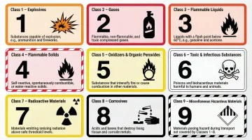
Different classes trigger different road restrictions — a route safe for Class 8 (corrosives) may be completely prohibited for Class 1 (explosives).
Why Standard GPS Fails
Google Maps explicitly states it is for "pleasure vehicles only" and excludes trucks of all sizes and hazmat restrictions. Waze similarly lacks truck-specific and hazmat routing capabilities. These tools route for speed or distance with no awareness of:
- Cargo type
- Bridge and tunnel hazmat bans
- City-specific ordinances
- PHMSA-designated preferred routes
Consequences of Using Non-Compliant GPS
Following the 2024-2025 DOT inflation adjustments, FMCSA civil penalties for knowing Hazardous Materials Regulations violations now reach up to $102,348 per violation, and up to $238,809 if the violation results in death, severe injury, or substantial property destruction.
The financial exposure is just the start. Using the wrong GPS also creates:
- Potential license suspension
- Liability in incident investigations
- Safety risks of routing dangerous cargo through populated or structurally incompatible areas
Knowing the stakes makes the tool selection decision clear. The next step is understanding what's actually available.
Three Categories of Hazmat-Capable Navigation
Not all GPS solutions handle hazmat requirements equally. The market breaks into three distinct tiers:
- Consumer and driver GPS apps that route for speed, not compliance — inadequate for hazmat use
- Dedicated truck GPS devices with built-in hazmat class settings and truck-specific road databases
- Enterprise routing APIs that plug into TMS platforms and fleet management software, enforcing hazmat restrictions at scale
For fleets managing multiple hazmat classes across different corridors, the API tier is typically the only option that keeps up.
Hazmat Truck Routing Regulations You Need to Know
Federal Regulatory Framework
49 CFR Part 397 requires carriers transporting placarded non-radioactive hazardous materials to use practicable routes — those that minimize risk to the public and environment. Operating convenience alone is not a valid basis for choosing an alternative route.
FMCSA's Role
The Federal Motor Carrier Safety Administration enforces compliance for motor carriers, requiring:
- Follow PHMSA-designated preferred routes for applicable hazmat classes
- Maintain accurate shipping papers at all times
- Ensure drivers hold a CDL with active Hazmat endorsement
The FMCSA maintains a National Inspection Out of Service rate for Hazardous Materials at 6.82%, actively monitoring and enforcing violations.
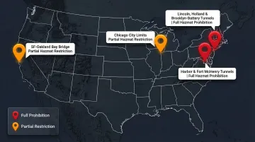
State and Local Regulations
Cities like New York, San Francisco, and Chicago layer additional restrictions on top of federal rules:
| Infrastructure | Governing Body | Key Hazmat Restrictions |
|---|---|---|
| Lincoln, Holland, Brooklyn-Battery Tunnels (NY/NJ) | Port Authority NY/NJ / MTA | Strict prohibition on hazmat; no "Materials of Trade" exemption for propane |
| Baltimore Harbor (I-895) & Fort McHenry (I-95) Tunnels | MDTA | Prohibits all hazmat, explosives, radioactive materials, bulk gasoline, and bottled propane over 10 lbs per container |
| SF-Oakland Bay Bridge (I-80) | Caltrans / CHP | Prohibits Class A and B explosives and tank vehicles placarded "Flammable" |
| Chicago City Limits | City of Chicago | Title 15 municipal code restricts Class I flammable liquids to specific designated arterial routes |
A routing system that doesn't account for these tunnel bans and municipal codes puts carriers at risk of violations, fines, and — in worst cases — routing a placarded truck into a prohibited zone with no warning.
Must-Have Features in a GPS with Hazmat Routing
Cargo-Type Input and Dynamic Rerouting
The GPS must allow you to specify which of the 9 hazmat classes you're carrying, then automatically calculate and recalculate routes in real time that bypass all applicable restrictions for that specific cargo.
Road-Level Restriction Data
The system's underlying map data must encode hazmat prohibitions at the road segment level:
- Tunnel bans (e.g., Baltimore Harbor Tunnel for Class 1 explosives)
- Bridge weight and hazmat limits
- Urban restricted zones
- Not just generic truck height or weight data
Compliance Alerts and Violation Warnings
Before and during a trip, the GPS should proactively warn drivers if a planned or suggested route passes through a restricted area for their cargo type and flag alternate compliant paths.
Integration with Truck-Specific Parameters
Hazmat routing should stack with other truck constraints simultaneously:
- Vehicle height
- Weight
- Length
- Axle configuration
The resulting route must be compliant on all dimensions at once.
Offline Capability
Hazmat trucks often operate in remote or low-connectivity corridors. The GPS must navigate and enforce hazmat routing rules offline, without degrading to generic routing when connectivity drops.
For Enterprise Fleets
An API-based routing engine that accepts hazmat class as a routing parameter — alongside vehicle specs — lets dispatchers and TMS platforms pre-validate routes before a driver gets in the cab.
NextBillion.ai's truck-compliant routing API supports hazmat-aware routing parameters, giving logistics software providers and large fleets a way to embed compliant route generation directly into their operations platforms. Key capabilities include:
- Accepts hazmat class alongside vehicle specs as routing parameters
- Over 50 configurable constraints for precise, multi-dimensional compliance
- Embeds directly into TMS and dispatch platforms for pre-trip route validation
Top GPS Systems and Solutions for Hazmat Truck Routing
Garmin dezl Series
Garmin's truck-specific devices (dezl OTR800, OTR1000) include hazmat settings where drivers select their cargo type — explosives, flammable, poison, etc. — and the device reroutes to avoid restricted roads. Backed by Garmin's offline map database with built-in Wi-Fi for updates.
$349.99 to $899.99 MSRP depending on screen size and features.
Rand McNally TND and DC Series
Rand McNally's commercial truck GPS units support hazmat routing with truck-specific restriction databases. They integrate with ELD and IFTA tools, making them a stronger compliance-oriented choice for long-haul regulated carriers. Lifetime map updates are included for the useful life of the device.
CoPilot Truck (ALK Technologies)
A software-based solution available on tablets, phones, and in-cab units that includes full hazmat routing based on PC*MILER data — widely used by commercial carriers for its compliance pedigree with North American route restrictions. Supports 30 hazmat categories and offline capability.
Hammer and TruckMap (Mobile Apps)
Free or low-cost mobile apps that include hazmat load type selection for route planning:
- Hammer: Allows toggling hazmat load information alongside truck type and trailer size; Premium tiers $4.99/mo or $49.99/year
- TruckMap: Supports hazmat preferences alongside weight and clearance filters; covers over 600,000 truck facilities; Free for drivers with in-app purchases up to $69.99
Suitable for owner-operators or small fleets without dedicated hardware budgets.
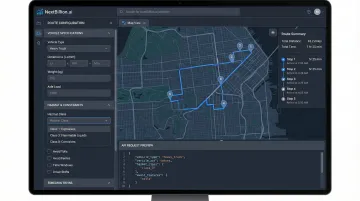
NextBillion.ai (Enterprise Routing API)
For fleet management software companies, telematics providers, and large carriers who need hazmat-aware routing embedded directly into their own platforms, NextBillion.ai's route optimization API supports truck-compliant routing with vehicle-specific constraints including hazmat parameters. The API handles 50+ hard and soft routing constraints, supports multi-stop optimization at scale, and integrates with major fleet management systems including Samsara, Geotab, and Motive. Operations teams building or customizing a TMS or dispatch tool can programmatically generate compliant routes without managing GPS hardware.
Pay-as-you-go or custom quote depending on volume.
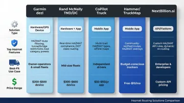
Here's a quick comparison across all five options:
| Solution | Type | Hazmat Support | Best For | Price Range |
|---|---|---|---|---|
| Garmin dezl | Dedicated hardware | Cargo type selection, restricted road avoidance | Individual drivers, small fleets | $349.99–$899.99 |
| Rand McNally TND/DC | Dedicated hardware | Restriction database + ELD/IFTA integration | Long-haul regulated carriers | $329.99–$549.99 |
| CoPilot Truck | Software (tablet/phone) | 30 hazmat categories, offline capable | Commercial carriers, compliance-focused ops | $119.99/year |
| Hammer / TruckMap | Mobile apps | Load type toggles, weight and clearance filters | Owner-operators, small fleets | Free–$69.99 |
| NextBillion.ai | Routing API | 50+ constraints, programmatic multi-stop routing | Fleet software teams, enterprise carriers | Pay-as-you-go / custom |
How to Choose the Right Hazmat GPS for Your Fleet
Match the Solution Type to Your Operational Model
Different operational models need different tools:
- Owner-operators and small fleets: Dedicated hardware (Garmin dezl, Rand McNally) or mobile apps (Hammer, TruckMap) handle in-cab navigation well
- Mid-to-large fleets with central dispatch: A TMS-integrated or API-based routing engine generates compliant routes before assignment — not just at the wheel
Evaluate Map Data Currency and Restriction Coverage
Road restriction data is the core of any hazmat routing tool — outdated maps mean compliance gaps. Ask vendors:
- How frequently are hazmat restriction layers updated?
- Do they cover both federal preferred routes and state/local ordinances?
- How quickly are new restrictions (e.g., post-incident tunnel bans) reflected in routing?
Look for vendors that offer both scheduled base map updates and rapid patch releases for time-sensitive restrictions — annual-only updates won't catch mid-year tunnel bans or emergency route changes.
Once you've confirmed data quality, factor in the full cost picture — not just the sticker price.
Consider Total Cost of Ownership
Hardware devices:
- Upfront cost: $329 to $899
- Typically include lifetime map updates
- No recurring subscription fees
Mobile apps:
- Minimal upfront hardware costs
- Recurring subscriptions: $50 to $120/year per driver
Enterprise APIs:
- Custom quote or volume-based pricing
- For fleets with multiple vehicles, per-vehicle or flat-fee pricing (rather than per-API-call) cuts routing costs as vehicle count grows — sometimes by 40–60% compared to per-call models
Frequently Asked Questions
Which truck GPS systems offer HazMat routing?
Dedicated devices like the Garmin dezl series and Rand McNally TND/DC, along with commercial apps like CoPilot Truck, Hammer, and TruckMap, all support hazmat routing. Enterprise fleets can also use routing APIs like NextBillion.ai to generate compliant routes programmatically and embed them directly into their TMS platforms.
What GPS has truck routes?
Dedicated truck GPS devices (Garmin dezl, Rand McNally) and commercial apps (CoPilot, Sygic Truck, TruckMap) are built for truck-specific routing, accounting for height, weight, axle load, and road restrictions. Standard consumer GPS tools like Google Maps or Waze are designed for passenger vehicles and lack these capabilities.
Do Google Maps and Waze support truck routes?
No. Neither Google Maps nor Waze supports hazmat routing or truck-specific restrictions like bridge heights, weight limits, or hazmat-prohibited roads. Both tools are built for consumer navigation and should not be used as the primary navigation tool for commercial hazmat transport.
Do all Garmin GPS devices support truck routes?
Only Garmin's dezl series is built for commercial trucks with hazmat and truck-routing features. Standard Garmin consumer devices — including the DriveSmart and nüvi lines — do not include truck-specific or hazmat routing capabilities.
What are the US regulations for hazmat truck routing?
Under 49 CFR, PHMSA requires hazmat carriers to use practicable routes that minimize public risk, while FMCSA enforces compliance including CDL Hazmat endorsements and proper shipping papers. State and local authorities layer on additional restrictions for tunnels, bridges, and urban corridors.